

Drainage Class IX Geography Notes: The revision-notes of the chapter ‘Drainage’ of Class IX are given below. These notes will help in understanding the chapter.
Drainage is the process by which water is drained from an area which we call the river system of an area. The river system includes the main river along with its tributaries. The area drained by a single river is known as drainage basin.
Drainage Class IX Geography Notes for revision
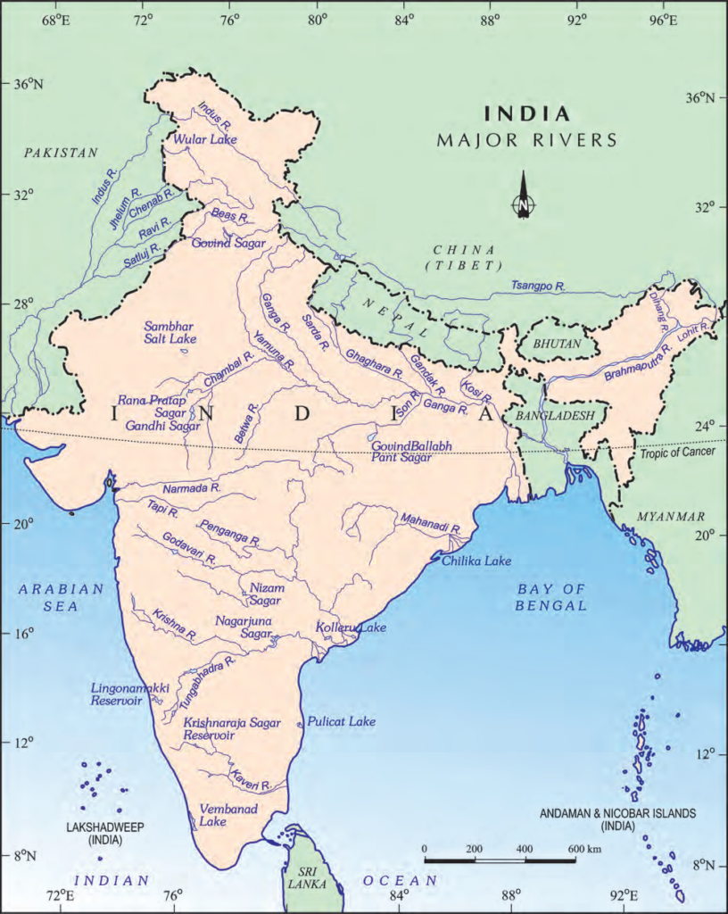
Map: Major Rivers and lakes
Drainage
- The term drainage describes the river system of an area.
- The area drained by a single river system is called a drainage basin.
- Any elevated area, such as a mountain or an upland, separates two drainage basins, such an upland is known as a water divide.

- Amazon River is the world’s largest Drainage Basin.
Drainage System
- The Drainage systems of India are mainly controlled by the broad relief features of the subcontinent.
- The Indian rivers are divided into two major groups: the Himalayan rivers and the Peninsular rivers.
- Most of the Himalayan rivers are perennial, therefore, they have water throughout the year
- A large number of Peninsular rivers are seasonal, as their flow is dependent on rainfall.
The Himalayan Rivers and Major River System
- The Important Himalayan rivers are the Indus, the Ganga and the Brahmaputra.
- These rivers are long, and re-joined by many large and important tributaries.
- A river along with its tributaries may be called a river system.
The Indus River System
- The river Indus rises in Tibet, near Lake Manasarovar. Flowing west, it enters India in the Ladakh district of Jammu and Kashmir. It forms a picturesque gorge in this part.
- It flows through Baltistan and Gilgit and emerges from the mountains at Attock.
- The Satluj, Beas, Ravi, Chenab and Jhelum join together to enter the Indus near Mithanlit in Pakistan.
- The river has several tributaries such as the Zaskar, Nubra, Shyok and Hunza.
- The Indus flows southwards, eventually reaching the Arabian Sea.
- With 2,900 kms, the Indus is one of the longest rivers of the world.
- According to the regulations of the Indus Water Treaty (1960), India can use only 20 per cent of the total water carried by Indus River System.
The Ganga River System
- The river Ganga is over 2,500 kms long.
- The headwaters of the Ganga, called the Bhagirathi, is fed by the Gangotri Glacier and joined by the Alaknanda at Deva Prayag in Uttarakhand.
- The Ganga is joined by many tributaries from the Himalayas, such as the Yamuna, the Ghaghara, the Gandak and the Kosi.
- The Chambal, the Betwa and the Son are the main tributaries from peninsular upland side.
- The river bifurcates in West Bengal and the Bhagirathi – Hooghly flows Southwards through the deltaic plains into the Bay of Bengal.
- The Ganga and Brahmaputra rivers form the world’s largest and fastest growing Delta called Sunderban Delta which is home to the Royal Bengal Tigers.
- The Namami Gange Programme is an Integrated Conservation Mission approved as a ‘flagship programme’ by the Union Government in June 2014 to accomplish the twin objectives of effective abatement of pollution, conservation and rejuvenation of the national river, Ganga. You may explore about this project at https://nmcg.nic.in/ NamamiGanga.sspx#
The Brahmaputra River System
- The Brahmaputra rises in Tibet, East of Manasarovar Lake, very close to the sources of the Indus and the Sutlej.
- It is slightly longer than the Indus and most of its course lies outside India.
- Brahmaputra is known as Tsang Po in Tibet and Jamuna in Bangladesh.
- The Brahmaputra has a braided channel in its entire length in Assam and forms many Riverine Islands.
- Every year, during the rainy season, the river overflows its banks, causing widespread devastation due to floods in Assam and Bangladesh.
Peninsular Rivers
- A large number of the Peninsular rivers are seasonal, as their flow is dependent on rainfall.
- During the dry season, even the large rivers have reduced flow of water in their channels.
- The Peninsular rivers have shorter and shallower courses as compared to their Himalayan counterparts.
- Some of them originate in the Central Highlands and flow towards the west.
- Most of the rivers of peninsular India originate in the Western Ghats and flow towards the Bay of Bengal.
- The rivers falling in the Bay of Bengal make deltas at their mouths.
- The Narmada and the Tapi are the only long rivers, which flow westward and make estuaries
- The Peninsular rivers include the Narmada Basin, the Tapi Basin, the Godavari Basin, the Mahanadi Basin, the Krishna Basin and the Kaveri Basin.
The Narmada Basin
- The Narmada rises in the Amarkantak Hills in Madhya Pradesh.
- Some of the notable locations along the Narmada River – The Marble Rocks, near Jabalpur, where the Narmada flows through a deep gorge, and the Dhuadhar Falls, where the river plunges over steep rocks.
- The Narmada basin covers parts of Madhya Pradesh and Gujarat.
- The Narmada River conservation mission has been undertaken by the government of Madhya Pradesh by a scheme named Namami Devi Narmade.
The Tapi Basin
- The Tapi rises in the Satpura ranges, in the Betul district of Madhya Pradesh.
- Its basin covers parts of Madhya Pradesh, Gujarat and Maharashtra.
The Godavari Basin
- The Godavari is the largest Peninsular River.
- It rises from the slopes of the Western Ghats in the Nashik District of Maharashtra. Its length is about 1,500 km.
- The drainage basin of the Godavari River is the largest among the Peninsular rivers.
- Important tributaries of the Godavari are the Purna, Wardha, Pranhita, Manjra, Wainganga and Penganga.
- The Godavari River is also known as the ‘Dakshin Ganga’ because of its length and the area it covers.
The Mahanadi Basin
- The Mahanadi rises in the highlands of Chhattisgarh.
- It flows through Odisha to reach the Bay of Bengal.
The Krishna Basin
- It rises from a spring near Mahabaleshwar,
- the Krishna River flows for about 1,400 km and reaches the Bay of Bengal.
- The Tungabhadra, Koyana, Ghatprabha, Musi and Bhima are some of its tributaries.
The Kaveri Basin
- The Kaveri rises in the Brahmagri range of the Western Ghats and it reaches the Bay of Bengal.
- The main tributaries are the Amravati, the Bhavani, the Hemavati and the Kabini.
- Its basin drains parts of Karnataka, Kerala and Tamil Nadu.
- The river Kaveri makes the second biggest waterfall in India, known as Sivasamudram. The hydroelectric power generated from the falls is supplied to Mysuru, Bengaluru and the Kolar Gold Field.
Lakes
- Lake is a large area of water surrounded by land.
- Lakes of large extent are called the seas, like the Caspian, the Dead and the Aral seas.
- India has many lakes differing by size and characteristics.
- Most lakes are permanent while others contain water only during the rainy season.
- There are some of the lakes which are formed or we can say are the result of the action of glaciers and ice sheets, while the others have been formed by wind, river action, and human activities.
- Some lakes are natural and some are artificial.
- The Wular Lake in Jammu and Kashmir is the largest freshwater lake in India.
- Damming forms reservoir artificial lakes such as the Guru Gobind Sagar Lake (Bhakra Nangal Project). formed by the damming of the rivers for the generation of Hydel Power.
Formation of Lakes
(i) Some lakes are formed due to glaciers and ice sheets. They are found in Himalayan regions.
(ii) Oxbow lakes are formed due to cut-offs made up of a meandering rivers across a flood plains.
(iii) Spits and bars form lagoons in the coastal areas, e.g. the Chilka lake, the Pulicat lake, the Kolleru lake.
(iv) Some lakes are formed in the rainy season like the lakes in the basins of inland drainage of semi-arid regions e.g. Sambhar Lake.
(v) Some lakes are formed due to tectonic activities e.g., Wular lake in Jammu and Kashmir.
(vi) There are artificial lakes formed because of the damming of the rivers for the generation of hydropower such as Guru Gobind Sagar.
Classification of lakes in India
(i) Freshwater lakes: They are mainly found in Himalayan region. They are of glacial origin. They are formed when glaciers dug out a basin, which was later filled with snowmelt. The Wular lake is the largest fresh water lake of India. Other freshwater lakes are the Dal Lake, Bhimtal, Loktak and Barapani.
(ii) Salt water lakes: They are mainly found in Rajasthan. The Sambhar Lake in the desert region of Rajasthan is a salt water lake. Its water is used for making salt.
(iii) Lagoon: It is a shallow body of water separated from the sea by a narrow strip of land or by a sand bar. Spits and bars form lagoons in the coastal areas. The Chilka Lake in Odisha and the Pulicat lake near Chennai are examples of lagoons on the eastern coast of India.
Importance of Lakes
- A lake helps to regulate the flow of a river.
- During heavy rainfall, it prevents flooding, and
- During the dry season, it helps to maintain an even flow of water.
- Lakes can also be used for developing Hydel Power.
- They moderate the climate of the surroundings; Maintain the Aquatic Ecosystem, Enhance Natural Beauty,
- Lakes also help Develop Tourism and Provide Recreation.
Role of rivers in the economy
- Rivers have been of fundamental importance throughout the human history.
- Water from the rivers is a basic natural resource, essential for various human activities.
- The river banks have attracted settlers from ancient times. These settlements have now become big cities.
- Using rivers for Irrigation, Navigation, Hydro-Power Generation is of special significance – particularly to a country like India, where Agriculture is the major source of livelihood of the majority of its population.
River Pollution
- The growing domestic, municipal, industrial and agricultural demand for water from rivers naturally affects the quality of water. As a result, more and more water is being drained out of the rivers reducing their volume.
- On the other hand, a heavy load of untreated sewage and industrial effluents are emptied into the rivers. This affects not only the quality of water but also the self-cleansing capacity of the river.
- main sources of water pollution are – disposal of garbage, untreated sewage and other waste in liquid form of houses and factories, and disposal of thermal power plants.
- Concern over rising pollution in our rivers led to the launching of various action plans to clean the rivers.
very useful but I expect this with states boder’s