

Notes of the chapter ‘Resources and Development’ Class 10 NCERT Geography: The notes are meant for a quick revision of the chapter ‘Resources and Development’. The headings and subheadings in the notes will help students in understanding as well drafting good and high scoring answers for the Board Exams.
Click here for more such study materials
Resources and Development Notes
Natural Resources
Air, water, land, and other materials that are freely available in the natural environment and satisfy human needs are known as natural resources. These things are gifts of nature available for human utilisation. · Any substance is termed as a resource when a utility is attached to it. · Resources can be broadly classified as natural and human resources.
What are Natural resources?
- Substances available in nature and used directly in raw form without much modification are known as natural resources—for example, soil, water, minerals.
- Natural resources are of two types, namely, renewable and non-renewable resources.
- Renewable resources like water, sun, flora, and fauna are inexhaustible and can be replenished quickly.
- Renewable resources are of two types: continuous or flow resources like water and air and biological resources like plants and animals.
- Non-renewable resources like metals and fossil fuels get exhausted by use, and they take over millions of years to replenish themselves.
- Certain non-renewable resources, like metals, can be recycled to make other things, but they require processing.
- Coal or natural gas, or petroleum, once used, cannot be recycled as they cannot be put to use in any other form.
Human resources
- People use their skills and knowledge to transform elements of nature into resources. Thus, human beings are regarded as resources.
- Human resources can be broadly classified into structures and institutions and according to quantity and quality.
- Human beings transform materials available in the environment and turn them into resources with the help of technology. For example, human beings extract minerals from the earth using technology and make utensils, tools, currency, jewellery.
- In the process, they create structures and institutions essential for economic activity.
- The number of people in the country represents the quantity of population. Factors like education, healthcare, skill enhancement, and food security help improve life quality.
Nature, technology, and institutions are interdependent
- Nature provides resources, but technology and institutions like industries make it valuable.
- Technology is critical for the optimal utilisation of natural resources.
- In the absence of institutions, resources are of no value nor can technology be developed.
Classification of Natural Resources
Q. Hint: How are natural and human resources classified?
Resources can also be classified as follows:
Biotic and abiotic resources based on origin
- Biotic resources: All the resources that have life and are obtained from the biosphere (domain) of the earth are known as biotic resources. For example, human beings, plants, animals, fisheries. Biotic resources can be classified into producers, consumers, and decomposers.
- Abiotic resources: All the non-living components present in the ecosystem are known as abiotic resources. For example, rocks, metals, minerals. Abiotic resources can be classified into renewable and non-renewable resources.
Renewable and non-renewable based on exhaustibility
- Renewable resources: The resources that can be renewed or reproduced in a short time are known as renewable resources. Such resources can be produced using physical, chemical, or mechanical processes. For example, solar energy, wind energy, water, forests, and wildlife. Resources like wind and water tend to flow through the ecosystem continuously. They are environment friendly.
- Non-renewable resources: These resources take millions of years to replenish. For example, fossils fuels and minerals are formed after millions of years. They are available in limited quantities as their rate of consumption is greater than the rate of renewal. Many non-renewable resources are recyclable, such as metals. By contrast, fossil fuels are not recyclable and get exhausted with use over time.
Individual, community, national and international based on ownership
- Individual resources: The resources that are owned privately by an individual are known as individual resources. For example, farmland, plantations, pasture lands, ponds in rural areas , and houses, bungalows, cars in urban areas.
- Community resources: The resources that are available for use by all community members are known as community resources. For example, public parks, burial grounds, picnic spots, religious spots.
- National resources: The resources that are owned by the nation and come under the jurisdiction of the union government are known as national resources. For example, national highways, canals, railways, flyovers, forest and wildlife, water resources, minerals, political boundaries, and oceanic territory up to 22.2 kilometres. The government has legal powers to acquire privately owned land for undertaking developmental activities.
- International resources: The resources that international institutions control are known as international resources. For example, oceanic water beyond 200 nautical miles of the exclusive economic zone is an open ocean. Any country that wishes to use these resources needs to seek approval from international institutions.
Potential resources, developed resources, stock, and reserves based on the status of development
- Potential resources: Resources that are available but not fully utilised are known as potential resources. For example, Rajasthan and Gujarat states have enough potential to generate wind and solar energy, but at present, this energy is not produced to its full capacity.
- Developed resources: The resources that have been surveyed to estimate their quantity and quality in a particular region are known as developed resources. However, the development of these resources depends on the availability of technology and economic feasibility.
- Stock: The resources that are available in nature but cannot satisfy human needs due to lack of necessary technology is known as stock. For example, water is rich in hydrogen, but it cannot be harnessed to produce energy due to the absence of technological know-how. Thus, hydrogen in water can be considered a stock resource.
- Reserves: The resources that can be used with technological advancement, but their use has not started yet, are resources reserved for meeting future needs. For example, water in dams and forests are reserves that can meet future requirements.
Sustainable Development of Resources
Q. Hint: Why is sustainable development of resources necessary for economic development?
Problems due to Irresponsible use of Natural resources
Natural resources are vital for human existence. They are needed to maintain the quality of life. Irresponsible use of these resources has led to many problems such as:
- Overuse of resources leading to their depletion.
- Division of society into rich and poor segments.
- Unplanned use of natural resources has resulted in some serious problems such as global warming, depletion of the ozone layer, environmental pollution, and land degradation.
- Global warming is the result of deforestation, where the trees are being cut at an enormous rate. This leads to the release of excess carbon dioxide into the atmosphere, causing global warming.
- Pollution of water and air due to human activities has led to environmental pollution.
- If the rate at which resources are getting depleted continues, our planet will be in danger in the future.
- Resource planning is needed to stop depletion of resources and for the sustainable existence of all forms of life on earth.
Sustainable Development
Sustainable development refers to development that takes place without causing any harm to the environment and without compromising on the needs of future generations. To achieve the goal of sustainable development, two major events were held on a global level:
- Rio de Janeiro summit 1992
- Agenda21
Rio de Janeiro summit 1992
- In June 1992, the first International Earth Summit was held in Rio de Janeiro in Brazil. The Summit was held to address the urgent problem of environmental protection and socio-economic development at the global level.
- A declaration on Global Climatic Change and Biological Diversity was signed by the global leaders attending this summit.
- The main purpose of the Summit was to address the problems of environmental protection and socio-economic development at the global level.
- The Rio Convention endorsed the global forest principles and adopted Agenda 21. This was done to achieve sustainable development in the 21st century.
Agenda 21
- Agenda 21 aims at achieving global sustainable development.
- The main purpose of the agenda is to fight and overcome environmental damage, poverty, and disease through global cooperation.
- Agenda 21 aimed to overcome these problems through global cooperation.
- The main objective of Agenda 21 was that every local government should form its own local Agenda 21 to overcome the problems collectively at the global level.
Resource Planning & Conservation
Q. Hint: What are the different steps involved in the complex process of resource planning?
Need of resource planning:
- Natural resources are free gifts available for use to mankind.
- It is the duty of each individual to use resources in a planned manner to avoid waste and depletion.
- Resource planning is a strategy that allows the wise use of resources.
- The distribution of resources is uneven in India. For example:
- Coal and other minerals are found in abundance in Jharkhand, Chhattisgarh, and Madhya Pradesh.
- Rajasthan has ample wind and solar energy but lacks water resources.
- Due to such uneven distribution of resources, there is a need for balanced resource planning at the national, state, regional and local levels so that all the resources in the country can be used sustainably.
Steps of resource planning:
- Resource planning is a complex process that involves the following steps:
- Identify resources and make an inventory.
- Create a plan based on appropriate technology, skilled labour force, and institutional requirement.
- Align it with national development plans.
Availability of resources and Development:
- Resource planning in India dates back to the First Five Year Plan made after independence.
- The development of any region depends on the resources available in that area. Lack of technology and institutions may also hinder the optimal utilisation of resources, thus slowing the development of the area.
- Historical facts show that resource availability in a particular region has led to the establishment and development of colonies in that area.
- Regions rich in resources have attracted foreign invaders.
- The technological advancement of certain colonies has helped them to establish their supremacy over weaker sections. It has also helped them to exploit the resources of the weaker regions.
- Inappropriate use and overconsumption of resources have led to socioeconomic problems and environmental pollution. This calls for resource conservation from a grassroots level.
Resource conservation
- Resource conservation was a major concern for leaders and thinkers in the past. Mahatma Gandhi said, ‘There is enough for everybody’s need and not for anybody’s greed.’
- Mahatama Gandhi held the greediness of individuals and the exploitative nature of modern technology to be the root causes of the depletion of resources at the national level.
- He was against mass production and believed that production should be by the masses. It would generate more employment and would avoid the depletion of resources.
- The concept of resource conservation was first advocated at the international level by the Club of Rome in 1968.
- In 1974, Gandhian Philosophy was presented by Schumacher in his book titled Small is Beautiful.
- The Brundtland Commission Report of 1987 first introduced the concept of sustainable development and argued its importance as a means of resource conservation.
- The meaning of sustainable development as a means of resource conservation was published in a book named Our Common Future.
- A similar significant contribution was made in the first Earth Summit held in 1992 at Rio de Janeiro, Brazil, where a declaration was signed by global leaders on Global Climatic Change and Biological Diversity.
Land Resources & Land Use Pattern
Q. Hint: How is land used in different ways in India?
Land – a valuable resource
- Land is a vital natural resource of use to humankind.
- Three-fourths of the earth’s surface is covered with water, and only one-fourth is land. This land can be categorised into plains, mountains, plateaus, islands, and other geographical features.
- Population growth and urbanisation have led to the misuse of land in many ways. Since the land available for use is limited, it is necessary to use this resource with careful planning.
- In India, 43% of the total land area is plains, 30% are mountains, and 27% are plateaus.
- Plains are the most populated regions in the country as they facilitate agricultural activities and the establishment of industries. For example, the Gangetic plains.
- Mountains offer scenic beauty and promote tourism. They are also sources of many perennial rivers—for example, the Himalayas, Dehradun, Mussoorie.
- Plateaus are rich in mineral deposits, fossil fuels, and forests—for example, the Deccan Plateau, the Chhota Nagpur Plateau.
Land utilisation
The land is utilised for the following purposes:
- Forests
- Land not available for cultivation: utilised for the construction of settlements, factories, roads, and quarries.
- Other uncultivated lands: permanent pastures, grazing land, and culturable wasteland.
- Fallow lands: arable land not sown for one year or less.
- Net sown area: total cropped area.
Factors affecting the land use pattern in India
- Various factors determine the land use pattern in India. These factors are as follows:
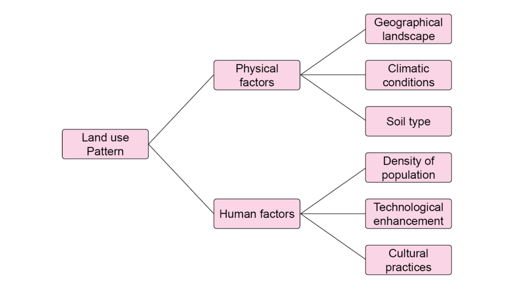
Land use pattern in India:
- The total geographical area of India is 3.28 million sq. km.
- Data for land use in India is only available for 93% of the total land within the country. Data are not available for the north-eastern states of India except Assam and for parts of Jammu and Kashmir that are occupied by Pakistan and China.
- Over the years, the land use pattern in India has changed. The percentage of permanent pasture land has decreased.
- Due to poor soil quality and the high cost of cultivation, fallow lands are cultivated twice or thrice in about two to three years.
- The percentage of the net sown area (NSA) rises to 54% if fallow lands are also counted as cultivated.
- A few states in India have more NSA than others. For example, Punjab and Haryana have more than 80% of total land as NSA, while Arunachal Pradesh, Mizoram, Manipur, Andaman, and the Nicobar Islands have only 10% of total land as NSA.
- According to a report by National Forest Policy in 1952, the total forest land in the country is much below the minimum level of 33% of the total geographical area.
Land Degradation and its Conservation
Q. Hint: How have human activities degraded land in India, and how can it be conserved?
- Land degradation refers to the reduction in the productivity of cultivable land or forest land.
- Land that is continuously being used without taking appropriate measures to retain its fertility becomes degraded in quality.
- Land degradation occurs because there is immense pressure to meet the demands of the growing population. It has many adverse effects on society and the environment, such as soil erosion, desertification.
Land degradation
- The land is one of the most important gifts of nature to human beings.
- The land is used by human beings from time immemorial. The same land will be used by the generations to come.
- Land fulfils most of our basic needs of food, shelter, and clothing.
- Growing population, urbanisation, and the establishment of infrastructure have led to the degradation of available land.
Causes of land degradation
- Human activities have created some serious problems. They have caused deforestation that has resulted in land degradation.
- Other human activities that have resulted in land degradation are:
- Excessive mining
- Mineral processing in factories
- Deforestation to carry out mining activities is the major cause of land degradation in Jharkhand, Chhattisgarh, Madhya Pradesh, and Odisha.
- In Gujarat, Rajasthan, Madhya Pradesh, and Maharashtra, overgrazing is the main cause of land degradation.
- In Punjab, Haryana, and western Uttar Pradesh, overirrigation has caused land degradation. Overirrigation in these areas leads to waterlogging, which increases the salinity and alkaline levels of the soil.
- Mineral processing activities, such as grinding limestone for the cement industry or calcite and soapstone for the ceramic industry, all generate dust in huge amounts. This dust spreads in the atmosphere and then settles on land. The dust hinders the penetration of moisture into the soil and eventually results in a dry land.
- Untreated industrial wastes is a significant cause of land and water pollution in recent years.
Land Conservation measures
The ways in which human beings can solve the problem of land degradation are:
- Afforestation, or planting more and more trees
- Avoiding overgrazing
- Planting shelter belts of plants to avoid soil erosion
- Growing thorny bushes in arid areas to restrict the direction and speed of sand dune build-up
- Limiting mining activities
- Treating industrial waste before discharging it into water bodies.
Soil
Q. Hint: What makes soil a living system?
Soil as a resource
- Soil is the loose particles found on the surface of the earth.
- Soil is an example of a natural renewable resource. Remember that natural resources can be renewable (can be replenished or replaced) or non-renewable (cannot be replaced or replenished).
- Soil is composed of rock particles, organic matter, waste, air, and living organisms.
Soil formation
(i) Forces of nature such as wind and rain cause the breakdown of rock particles and organic matter and produce soil.
(ii) The formation of soil depends on various factors:
- parent rock material
- climate
- relief
- natural vegetation
- time
- type of decomposed organic matter
- actions of natural agents such as wind, rain
(iii) All these factors determine the type and quality of the soil formed.
(iv) Each type of soil contains four elements in it.
- Mineral fraction (derived from parent rock)
- Organic matter (decayed dead plants and animals)
- Air
- Water
(v) The process of soil formation is known as pedogenesis.
(vi) It takes millions of years to form a few centimetres of soil. Thus, soil formation is a prolonged process.
Soil profile
- A vertical cross-section of soil shows layers of soil arranged parallel to the earth’s surface. The layers are known as horizons.
- Soil particles may remain at their original place of formation or may get transported to a different place by rain, wind, or other forces.
- The soil which remains at its original place is in situ.
- Soil is a valuable resource. It is used for agricultural activities, to make certain medicines, cosmetic products, and other valuable things.
- Soil is a finite resource because its loss and degradation are not reversible within the lifespan of human beings.
- Thus, the preservation of soil is essential for a sustainable future for human beings.
Classification of Soils
Q. Hint: How are soils of India classified into different types based on formation, colour, texture and properties?
On the basis of these factors, the soils of India can be classified as follows.
- Alluvial soil
- Black soil
- Red and yellow soil
- Laterite soil
- Arid soil
- Forest soil
Alluvial soils
Characteristics
- This soil is formed by three important Himalayan River systems – the Indus, the Ganga, and the Brahmaputra. Some of the alluvial soil in the coastal areas is formed by sea waves.
- Alluvial soil is made up of sand, silt, and clay.
- According to its age and maturity, alluvial soil can be categorised as old alluvial (Bangar) and new alluvial (khadar).
- Alluvial soils are very fertile as they contain potash, phosphoric acid, and lime in adequate proportions.
Location
- The Northern Plains have alluvial soils.
- Parts of Gujarat and Rajasthan, eastern coastal plains, particularly Mahanadi, Godavari, Krishna, and Kaveri River deltas, also have alluvial soils. This soil is known as deltaic alluvium. Along the coast, this soil is known as coastal alluvium.
Use
- Alluvial Regions with alluvial soil are densely populated as the soil is very fertile and supports agricultural activities.
- Alluvial soil is used to grow sugarcane, paddy, wheat, and other cereals and pulses.
Black soil
Characteristics
- Black soil is also known as regur soil.
- The nature of the parent rock material and climatic conditions primarily determines the black soil’s physical and chemical composition.
- Pedologists believe that this soil is formed from the solidification of lava flow.
- Black soil is made up of fine clayey particles. Thus, it can retain moisture.
- This soil is rich in nutrients such as magnesium, potash, calcium carbonate, and lime.
- It is highly water-retentive and becomes sticky when wet. Due to its sticky nature, this soil needs to be tilled immediately after the first monsoon shower or during the pre-monsoon period, or working in it becomes very difficult.
- Since it is poor in phosphorous content, it develops cracks during the hot season. These cracks help air (oxygen from the atmosphere) to penetrate deep into the soil.
Location
- This soil is found in the plateau region of Maharashtra, Saurashtra, Malwa, Madhya Pradesh, and Chhattisgarh.
- In the southeast, it is found in Godavari and Krishna River valleys.
Use: Cotton grows well in black soil, and thus it is also known as black cotton soil. Among other crops grown are wheat, jowar, sunflower, and millets.
Red and yellow soil
Characteristics
- Red and yellow soil is formed due to weathering of igneous crystalline rock.
- The soil is deficient in lime, phosphate, nitrogen, and humus content.
- The texture of the soil may vary from sandy to clayey.
- The iron in the soil gives it a red colour.
- When the soil is hydrated, it looks yellow.
Location
- This soil is found in regions that receive less rainfall, for example, the eastern and southern parts of the Deccan Plateau.
- It is also found in parts of Odisha, Chhattisgarh, the Ganga plains, and along the piedmont zone of the Western Ghats.
Use: With proper irrigation, crops such as cotton, wheat, rice, pulses, potatoes can grow well in this soil.
Laterite soil
Characteristics
- Laterite forms in tropical and subtropical climates where the weather switches from wet to dry.
- Laterite soil is formed due to the leaching of bricks due to heavy rain.
- Laterite soil is acidic with pH < 6.0 and lacks plant nutrients.
- Laterite soil can be rich in humus or can be poor in humus.
- In rich humus laterite soil, deciduous and evergreen forests are found. Where the humus content is low in laterite soil, sparse vegetation occurs.
- The soil particles are prone to erosion and degradation.
Location: Southern states of Karnataka, Kerala, and Tamil Nadu, Western Ghats region of Maharashtra, Odisha, some parts of West Bengal, Andhra Pradesh, and the north-eastern regions.
Use: With proper conservation techniques, tea, coffee, and cashew nuts can be grown in laterite soils.
Arid soil
Characteristics
- Arid soil has a sandy texture and is saline in nature.
- This soil may have high salt content in it. The salt is obtained by evaporating the water from the soil.
- The dry climate and high temperature accelerate the evaporation process, making the soil dry, and causes loss of humus as well.
- The lower horizons of the soil contain kankar due to higher calcium content.
- Proper irrigation facilities can turn this soil into cultivable soil.
Location: Parts of Rajasthan and Gujarat.
Use: Crops that can withstand dry climatic conditions such as barley, millets, maize are grown in this soil.
Forest soil
Characteristics
- Forest soil is found in mountainous regions with rainforests.
- The texture of the soil depends on the climatic condition of the hilly area where it is found.
- The soil is coarse-grained in the upper regions of the mountain and loamy and silty in the valleys.
- The soil is acidic and low in humus in the snow-covered areas of the Himalayas. But this soil is fertile in the lower parts of the valleys, river terraces, and alluvial fans.
Location: The Himalayan region, Western and Eastern Ghats, and parts of the peninsular plateau region.
Use: The soil is suitable for tea and coffee plantations, spices, and some tropical fruits.
Soil Erosion & Conservation
Q. Hint: What causes soil erosion and what measures are used to prevent soil erosion?
Problems of soil in India
The soils in India suffer from various problems such as:
- soil erosion
- infertility
- desertification
- waterlogging
- salinity and alkalinity
- overexploitation of soil due to population growth
- encroachment of agricultural land into forests
Soil erosion
- Soil erosion is the removal of the top layer of the soil.
- It is caused by natural forces such as wind, rain, glacier movement.
- Soil formation and soil erosion simultaneously.
- A balance is struck between soil formation and soil erosion.
- Soil erosion is a serious threat to: agricultural productivity the economy of the country
Types of soil erosion
Soil erosion can be of two types:
- water erosion
- wind erosion
Effects of soil erosion due to rain and water
- Heavy rainfall may wash away soil and cause deep grooves in the land. Heavy downpour in a short time span results in more significant soil erosion. The same amount of rainfall, if distributed over a longer time, results in less soil erosion.
- These grooves, when enlarged, are known as gullies.
- These gullies turn land uncultivable, which land is known as badland.
- A deep gully bed of around 3 to 4 meters depth is known as a ravine.
- Removal of soil over a large area by running water causes sheet erosion. Sheet erosion is prominent on slopes that receive heavy rainfall.
- Soil erosion caused by tidal waves in coastal areas is known as sea erosion.
Effects of soil erosion due to wind
- The wind is a powerful agent of soil erosion.
- Wind erosion occurs in semi-arid lands with little or no rainfall.
- The rate of wind erosion is higher when the soil is: dry weakly aggregated lacks the growth of natural vegetation
Soil erosion due to human activities
Soil erosion is also caused by certain human activities: deforestation overgrazing faulty methods of agriculture such as shifting cultivation
(i) Deforestation – Overpopulation and its requirement for wood products leads to deforestation and causes soil erosion.
(ii) Overgrazing – During the dry summer season it causes soil erosion.
(iii) Wrong agricultural techniques – Faulty methods of agriculture also cause soil erosion. Some examples are:
- lack of crop rotation
- shifting cultivation
- ploughing up and down the hill slope
Soil conservation
Soil conservation is all the techniques used to prevent soil erosion. Various soil conservation techniques that can be used are as follows:
- Contour ploughing: Ploughing along the contour lines reduces the speed of flowing water and prevents soil erosion.
- Terrace farming: Slopes of hills are cut into terraces. Terraces reduce the flow of water down the slope and prevent soil erosion.
- Strip dropping: Strips of grass are grown between the crops to check the speed of the wind. Strip cropping reduces soil erosion caused due to wind.
- Shelter belts: Rows of trees are planted to reduce the speed of the wind. These rows of trees are known as shelter belts and act as a barrier to the flowing wind. This prevents erosion of soil to a great extent.